Petersfield community tree location survey
Identifying public places for planting trees
Andy J. Moffat1,2 and Phil Handley1
In 2016/17, the Petersfield i-Tree Eco survey was conducted to better understand the number and nature of trees in the Hampshire town and parish. The survey was commissioned not only because of a growing realisation that trees are an essential element of the structure and appearance of the town, but also in response to several pressures (e.g. development, health and safety concerns) that were posing significant risk to tree protection and even the continued presence of trees in certain localities.
The i-Tree survey was one of the first of its kind in the country for a market town, carried out exclusively by volunteers, and the report was well received at national, regional and local levels. Further information on the survey can be found in ARB Magazine 176 (spring 2017, pages 47–48).
A significant ‘take home message’ from the survey was that to maintain tree cover as it is, significant tree planting would be necessary to make good inevitable losses. And to achieve a canopy cover of 20%, based on existing canopy cover of 15.1%, nearly 20,000 extra trees were predicted. A question often, and naturally, asked in the face of such ambition is: where can such a large number of trees be planted? Without some attempt to answer it, ambitious planting projects are likely to fail. In 2019, Petersfield Society, the town’s civic society, decided to launch a follow-up to its i-Tree survey by encouraging Petersfield residents to participate in a survey to find suitable locations for new trees on public land.
Survey methodology
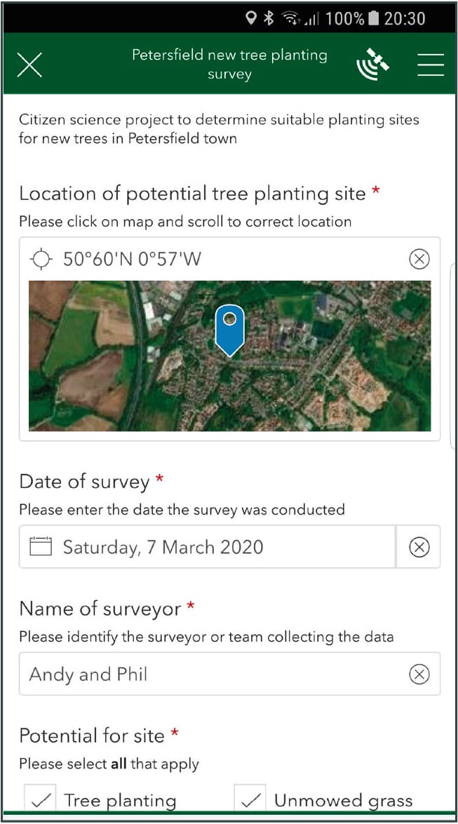
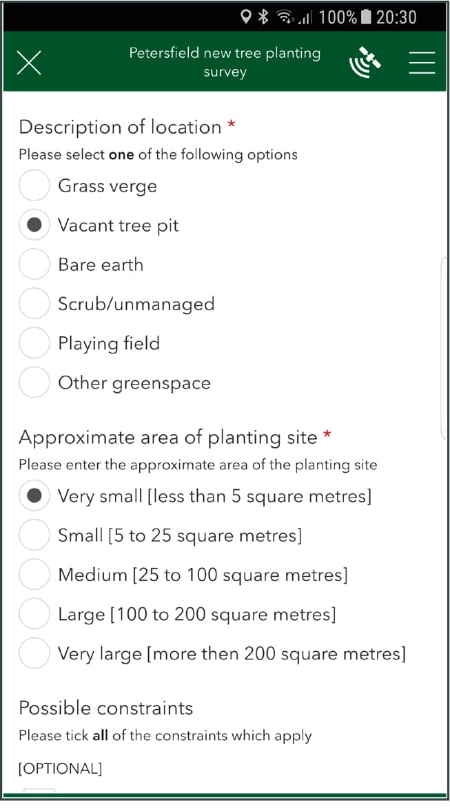
The survey used a smartphone app developed in ArcGIS Survey123 to allow easy entry of data. Basic information was sought about the location of the proposed tree planting site, the date of the survey, the name of the survey team, the potential of the site for reduced grass mowing, and the current land-use and the size of the site. Surveyors were also asked to note any visually obvious constraints, and to make any further comments in free text. A photograph of the site was mandatory, to help locate it again, as a useful element to aid decision-making and as survey quality control. Site data records were captured on the smartphone app for uploading onto an ArcGIS survey base map. Figure 1 shows images of two of the three screens used in the survey.
The Tree Location Survey was launched in March 2020, when 31 volunteers agreed to take part. Training was given in how to judge the potential of sites for tree establishment, how to download the app, and how to enter information. A survey risk assessment was discussed and distributed, and hi-vis vests were issued to participants. Twelve teams were created and maps were issued to each showing the area of the parish that they should cover. Surveying was completed in September 2020.
The ArcGIS platform allowed us to explore proposed tree locations in relation to selected environmental and cultural features in the town. Spatial information about the parish was kindly provided by Hampshire County Council and East Hampshire District Council (EHDC), whilst other datasets were derived from Defra, the Environment Agency, Forest Research, the Forestry Commission, the Office for National Statistics and the Ordnance Survey.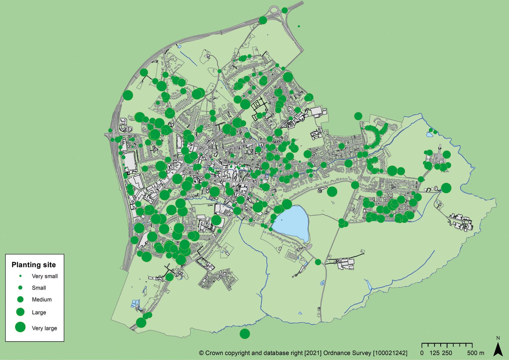
Figure 2: Location of tree location survey points. See Figure 1 for explanation of size classes.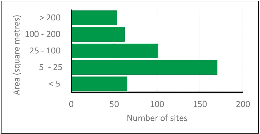
Figure 3: Size of survey points by size class.
Results
Figure 2 shows the distribution of 450 plots recorded by the volunteer surveyors. Of the sites visited, 95% were considered suitable for new tree planting, 38% were judged suitable for both tree planting and reduced grass mowing, and 5% for reduced grass mowing only. A majority of the roads in the town contain sites where new tree planting appears possible. A few roads are conspicuous for not having any recommended sites, but these are either well stocked with existing trees or there are few or no grass verges to consider planting into. Indeed, 70.0% of the survey records are based on perceived opportunities for tree planting on grass verges. Of the rest, 16.2% are located on land described as ‘Other greenspace’, 5.3% on ‘Playing fields’, 4.2% on ‘Unmanaged scrub’, 4.0% as ‘Vacant tree pits, and 0.1% on ‘Bare earth’.
The figures above give an indication of where the surveyors identified opportunities for tree planting by type of site. Many grass verges have room for trees to form linear patterns, or avenues, parallel to the road. However, other forms of greenspace can present opportunities for trees to be planted in rows or groups as well as single specimens.
Figure 3 shows the proportion of survey points by size class – just under half (48%) are in the medium, large and very large size classes and these offer the potential for considerable numbers of new trees. In total, we estimate that there are over 31,000 square metres of grass verges and other greenspace bordering roads and dwellings where there is potential for tree planting. These figures do not include significant areas of greenspace owned or managed by Petersfield Town Council.
Using survey data in the context of ecosystem service delivery
Modern tree policy in Britain is built around the maxim ‘The right tree in the right place for the right reason’. Choice of individual trees should be site specific. Firstly, the tree should grow well with minimal need for maintenance. Secondly, the tree should be appropriate for the space. Thirdly, the tree should fit into an overall strategy to enhance the resilience of Petersfield’s tree stock against threats such as climate change. In the constrained funding environment that most local authorities now operate in, it was felt essential to prioritise planting sites according to the onsite realities and the needs of the town. To do this, we identified key issues which currently affect Petersfield and where we have accurate models/ datasets to describe the problem. Below are two examples of ecosystem services that we explored in the study – others are contained in the survey report.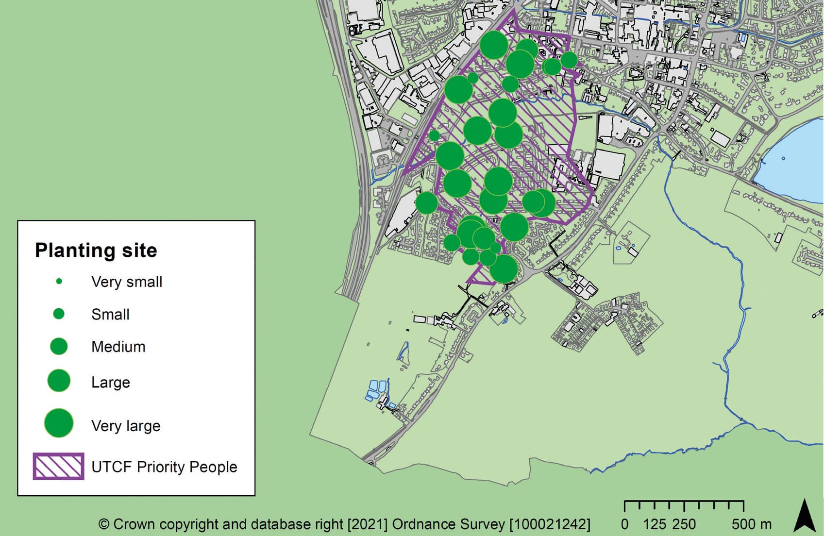
Figure 4: Location of potential sites for tree planting within the ‘Priority People’ area identified in the Urban Tree Challenge Fund.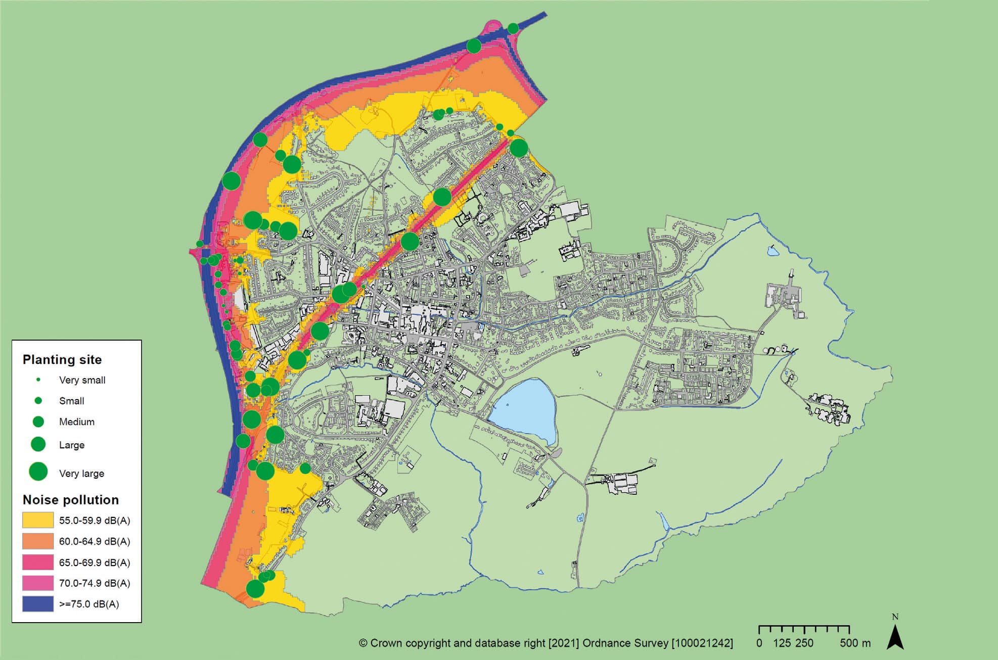
Figure 5: Location of potential sites for tree planting in relation to noise pollution. Noise data from Defra.
Considerable research and frontline evidence from well-wooded urban areas demonstrate that the health and well-being of residents are considerably enhanced if they live near to trees and woodland compared to those who don’t. Disadvantaged citizens and/or those living in areas of multiple deprivation benefit more when there are positive interventions to raise tree numbers – indeed, this is the basis of the government’s recent Urban Tree Challenge Fund. Figure 4 shows the area in Petersfield where deprivation is most acute, and the significant opportunities that the project surveyors identified for more trees in it. Given current initiatives for improving the environmental, social and economic conditions for citizens living in these areas, it could be argued that the district shown in Figure 4 should be given higher priority for more trees than well-wooded areas in Petersfield.
Another service that trees in urban areas can offer relates to noise attenuation – they can dampen noise generated by road and rail traffic. Figure 5 shows areas of Petersfield particularly prone to noise generated in these ways, based on modelling and mapping by Defra. It also shows public areas identified (in green) by the survey where tree planting, notably as groups or in belts, might help to reduce the noise for town dwellers, especially in the west of the town where the A3 trunk road forms the western boundary. Further attenuation of noise from the A3 is possible, but would depend on targeting tree planting on private land.
Impacts of the survey
The survey benefited from the use of smartphones to capture data, information and photographic images digitally and to use GIS to store and analyse them. The resulting datasets have proved capable of being shared with appropriate clients such as the Hampshire County Council (HCC) Highways Department. HCC has reported back on the usefulness and utility of this approach, and will be using the survey data to help plan tree planting in the town during the 2021/22 tree planting season. Indeed, an official in the department suggested that the approach taken in Petersfield should be extended across the county.
South Downs National Park Authority, East Hampshire District Council and Petersfield Town Council have already accepted and offered full support to the main findings of the survey report. A ‘Tree Summit’ will take place in late November when councils and relevant agencies will be invited to develop a joint action plan for tree planting in Petersfield parish. Other meetings are planned to share options for prioritising tree planting, using the ecosystems approach briefly outlined above. It is hoped that by bringing together the power of community-led evidence regarding the nature of trees in the town (the 2017 i-Tree Eco survey) together with up-to-date information on opportunities for new tree planting that a significant tree planting campaign can be generated and sustained over the next few years.
Summary
We have trialled a novel methodology using community citizen scientists to identify locations in Petersfield where new trees might be planted. The cost of carrying out the survey, based as it was on volunteers and smartphone technology, was negligible. To date, we judge the project to have been very successful, not least because it has significantly raised the profile of trees in the town. We would be happy to discuss how our project might be used as a basis for further surveys in other, similar towns. The Tree Location Survey report can be downloaded from www.petersfieldsociety.org.uk.

Dr Andy Moffat is a chartered forestry consultant specialising in urban forestry, a Research Fellow in Forest Research and Visiting Professor in the Department of Geography and Environmental Science at the University of Reading.

Phil Handley works as a GIS specialist for Forest Research, in the Urban Forest Research Group (UFoRG). He is interested in the structure and composition of the urban forest, and the benefits it accrues to society.
1 Forest Research.
2 Petersfield Society.
This article was taken from Issue 195 Winter 2021 of the ARB Magazine, which is available to view free to members by simply logging in to the website and viewing your profile area.
